
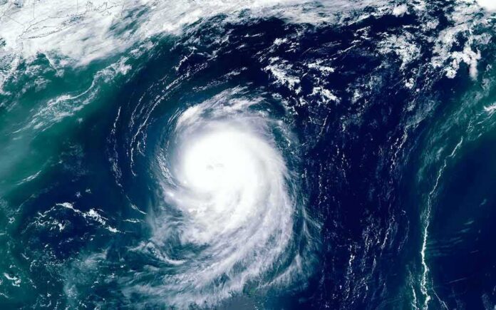
The National Hurricane Center says Hurricane Polo is rapidly strengthening and could reach major hurricane strength as it nears southwestern Mexico, raising real risks from flooding and mudslides.
Story Highlights
- Forecasters expect Polo to become a major hurricane early this week.
- Heavy rain could cause life-threatening flooding and mudslides in southwest Mexico.
- A Tropical Storm Watch is in effect for parts of southwestern Mexico.
- Southern California faces surf and rip current risks if long-period swells arrive.
NHC Confirms Rapid Intensification And Major Hurricane Potential
The National Hurricane Center reported that Polo continued to intensify on Monday and was expected to become a major hurricane on Tuesday. Forecast guidance showed strengthening while the system tracked near the coast of southwestern Mexico during the next few days. Official estimates even outlined high-end wind speeds in the short range, underscoring a credible path to major hurricane status. These advisories signal a high-impact period ahead for Mexico’s Pacific coast if the storm’s core approaches the shoreline.
Operational discussions from the National Hurricane Center described the environment as favorable for rapid gains in wind speed and organization. The center warned that Polo could reach peak strength while drawing closer to the coast, which raises the risk that intense rainbands could brush communities onshore. While intensity forecasts always carry uncertainty, the agency’s language on rapid strengthening is direct and firm. That clarity helps local leaders stage resources before roads flood or hillsides fail.
Mexico’s Primary Threat: Flooding, Mudslides, And Coastal Wind
The National Hurricane Center stated that heavy rainfall tied to Polo will affect coastal parts of southwest Mexico through Thursday, with potential for life-threatening flooding and mudslides, especially in steep terrain. That hazard often drives most storm-related deaths in this region, where saturated slopes can give way quickly. A Tropical Storm Watch was posted for sections of the southwest coast, reflecting concern for tropical-storm-force winds, dangerous surf, and coastal flooding in vulnerable low-lying areas.
Forecast tracks placed Polo near or just south of the coast of southwestern Mexico on Thursday, then south of the Baja California Peninsula on Saturday. Officials also noted that the core was forecast to stay offshore, which would limit the worst wind over land if that track holds. Still, outer rainbands and coastal squalls can reach well away from the center. Communities in river valleys, along unstable hillsides, and near small creeks should prepare for fast water rises and road washouts.
What It Means For Southern California: Surf, Not A Direct Hit
Eastern Pacific hurricanes often send long-period swells north, even when the center stays far offshore. That can raise surf, strengthen rip currents, and erode beaches in Southern California. The National Hurricane Center’s discussions for Polo focus on Mexico and the Baja Peninsula, not a United States landfall. Based on those forecasts, the most likely United States effect is coastal hazards, not direct wind or flooding rain. Local beachgoers should watch for coastal statements from the National Weather Service.
Past storms show how the message can get blurred. Media and social posts sometimes hype a broader “threat to the coast,” while forecasters keep the focus on verified hazards. The National Hurricane Center evaluates its forecasts after the season using best-track data, which accepts that some error is normal and expected. That reminder matters here. The right takeaway is simple: heed the clear risks the agency names now, and avoid reading more into the track than officials support.
Shared Frustrations And Practical Steps
Many Americans feel leaders talk big after disasters but fail to fix basics like alerts, drainage, and emergency access. People on the left and the right both see this pattern. Clear, early, and focused guidance helps break it. For residents in southwest Mexico, that means charging phones, checking family plans, clearing drains, and avoiding driving through flood zones. For Southern California, that means watching surf forecasts, swimming near lifeguards, and staying off jetties during high surf.
🚨 HURRICANE POLO ADVISORY | Sept. 21
Hurricane #Polo is undergoing rapid intensification off southwestern Mexico. As of the latest @NHC_Pacific update, Polo has strengthened to 80 mph winds with a central pressure of 977 mb, while moving slowly east at about 5 mph.
⚠️… pic.twitter.com/0Gb82mtcmV
— TheMarkNight (@TheMarkNight) September 21, 2026
Local governments can earn trust by posting road-closure maps in real time, pre-staging swift-water teams, and updating shelter options before rain begins. Businesses can secure loose outdoor items and protect inventory in low-lying areas. These are simple actions, not politics. They save lives when the rain hits hard. As Polo strengthens, officials have given enough detail to act now, even as some parts of the forecast remain uncertain by design. Preparedness beats panic every time.
Sources:
© nationalusnews.com 2026. All rights reserved.